Making sure our neighbourhoods are walkable by design
Sydney is on the cusp of its most significant urban transformation in generations. New tools like the low- to mid-rise SEPP, transit-oriented developments and the Pattern Book offer a golden opportunity to create walkable, liveable communities – where walking is the most enjoyable way to get around. This will not happen through density alone. There is an urgent need for an equivalent ‘pattern book’ at a neighbourhood scale to ensure that, as we transform these places, we embed a walkable urban form.
With NSW aiming to build 1.2 million homes under the Housing Accord, new policies will enable higher-density development, mostly around public transport. This is promising, but without attention to maximising walkability, these may amplify past mistakes that have resulted in car dependency. Done right, however, increasing density can deliver more walkable, liveable and loveable communities.
The Committee for Sydney, WalkSydney and Vivendi therefore released Putting Our Best Foot Forward: A Checklist for Walkable Density
The checklist is a diagnostic tool for assessing whether residential and mixed-use developments support walking. It is tailored for local and state governments, planners and developers to understand what makes places more walkable and how to improve outcomes for the communities who live and work in them.
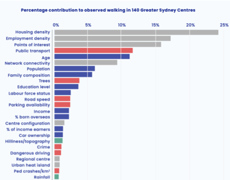
The checklist draws on a wide range of research, including groundbreaking work done by Vivendi Consulting for Transport for NSW to support a strategic business case for walking. This work uses regression analysis to combine built environment and demographic data with observed walking volumes obtained from processed mobile phone data, to identify and rank the factors that most influence whether people will walk in NSW - the Pedestrian and Walking System (PAWS).
What does the Checklist Score?
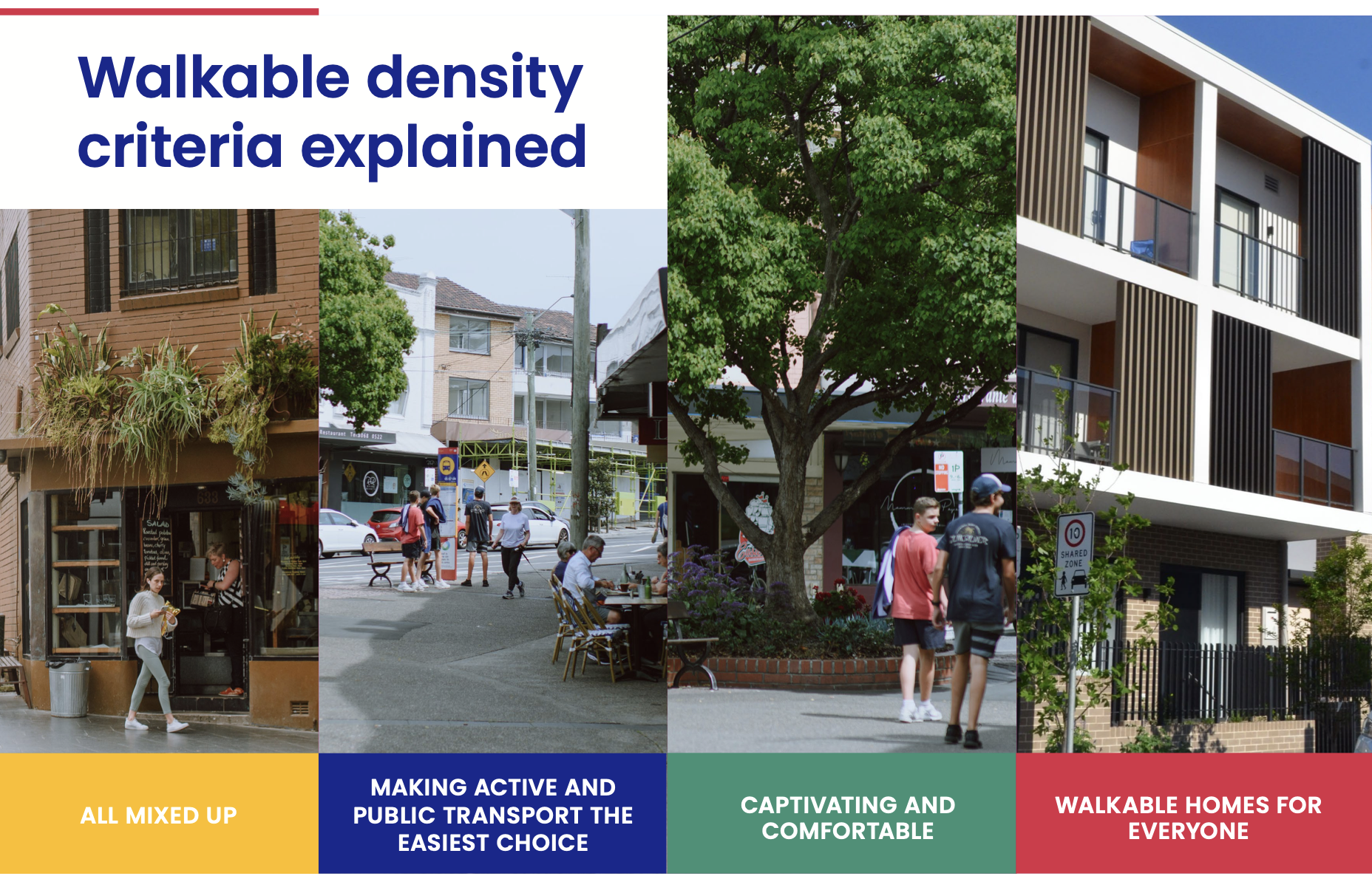
The checklist is a quick and practical tool that evaluates whether a development has the structural and spatial ingredients to support walking. It covers 25 factors across four themes:
Land use: All mixed up. Most walking occurs when there is a nearby place to walk to. Nearby daily destinations like schools, parks and fresh food are essential.
Check for: All residents are within a 10-minute walk to a park with a playground, a grocer or supermarket, primary school, childcare and sports space. A minimum gross density of 35 dwellings/hectare also supports local businesses.
Streets: Captivating and comfortable. The links between local places must be in place – footpaths, ramps and crossings. They must be safe from traffic and well lit.
Check for: All local streets are slow and calm, ideally 30kmh. Footpaths on each side of the street are 2 metres wide with pram ramps at intersections. Lighting and passive surveillance make it feel safe and there’s shading and places to rest. Walking routes are direct, convenient and comfortable with regular crossing points no more than 200 metres apart.
Network: Making active and public transport the easiest choice. Longer trips to citywide destinations must be enabled by cycleways or frequent public transport within easy reach.
Check for: At least 90% of residents are within walking distance of frequent public transport (a service every 15 minutes). Public transport operates from day one. There’s a shared path or cycleway on all streets over 40kmh, and separated cycleways if there’s more than 300 pedestrians an hour. Residential and commercial density is concentrated within 400 metres of public transport.
Buildings: Walkable homes for everyone. Enabling flexible work from home, occasional car use without owning a car, and high-rise family living all increase walkability and liveability of our new neighbourhoods.
Check for: Low- or no-car living with car share, unbundled car parking and secure bike parking. Work-from-home is enabled with studies and desk space in bedrooms; and there’s a range of housing options for diverse household types, with affordable housing, and no more than 80% studios and 1-2 bedroom apartments.
The Committee for Sydney publication explains each factor in detail
Scoring is straightforward: each of the 25 checklist items carries equal weight. Multiply by 4. A score of 80–100% indicates high walkability, with no more than two factors missing from any theme. While higher scores are better, it’s equally a diagnostic tool—which helps planners and designers to highlight gaps and point to solutions.
Walkability is structural, not cosmetic
The checklist draws on the Pedestrian and Walking System (PAWS) built by Vivendi Consulting for TfNSW. Vivendi’s analysis of 140 Greater Sydney centres confirms that walkability depends on getting the structural factors right - housing and job density, street permeability, and a mix of uses account for 54% of walking.
Demographics explain a further 27% of walking, while environmental factors like topography and weather account for just 1.4%. The remaining 18% are adaptable factors, such as public transport (most significantly, which is why TODs make sense), street trees and traffic speed.
The tipping points
Vivendi’s analysis also revealed clear tipping points. If planners can ensure these criteria are met, walking increases significantly.
Housing type: Where more than 30% of houses are freestanding, walking levels plummet. To support walking, at least 70% of homes should be semi-detached, duplexes, townhouses or apartments. This doesn’t require high-rise, rather ‘gentle’ density such as low- to mid-rise buildings do just as well. Suburbs like Balmain, Dee Why, Bondi and Summer Hill already meet this threshold with mostly two to four storeys.
Permeability: Street networks with many through-block links and intersections enable direct access. Long blocks, cul-de-sacs or barriers like highways and train lines are walkability killers. The tipping point is at around 45 intersections per square kilometre, or a maximum block length of 150 metres. In older suburbs with large blocks, introducing mid-block links, shared streets and pedestrian-priority crossings are essential.
Land use mix: Density is only effective when paired with proximity to daily needs like supermarkets, primary schools and parks. Even dense areas like Kellyville and Bella Vista remain car-dependent due to their homogenous residential nature and wide distribution of destinations, while suburbs like Ashfield, Rockdale and Kogarah thrive thanks to nearby shops, schools and parks. The low-mid rise SEPP is a step in the right direction in recognising the importance of centres, as well as transport. Unsurprisingly, if you can’t walk to daily needs, you’ll need to drive.
If you’d like to know more about PAWS or evaluate a project for its walking potential, come and speak to us below!


